Mardi 9 novembre
Bye bye Arguni ! Hello Bitsjari !
Par Olga Otero,  Changement de Teluk toute ! On est sorti de la Teluk Arguni vers 16h, on a longé la façade maritime de l’anticlinal auquel s’adosse la ville de Kaimana et l’on va arriver de l’autre côté dans la Teluk Bitsjari. En tout 4 ou 5h de bateau. La matinée a été occupée par le bouclage des chantiers dans la basse vallée d’Arguni, à proximité du bateau. Derniers affleurements, pieds dans la gadoue pour Unggul, Budi et moi, gentiment accompagnés à terre par notre piroguier en titre et son fils adorable.
 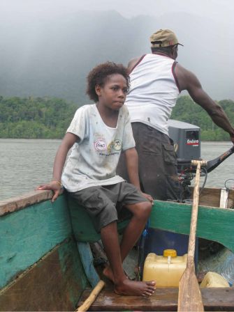 Une pluie battante s’est installée en milieu de matinée sur la baie pour ne s’arrêter que vers midi. C’est le moment que l’on a choisi pour rentrer : juste à temps pour le repas : poissons grillés, feuilles de manioc, et riz ; superbes (et délicieuses) bananes en désert. C’est aussi le moment de ranger et conditionner ce qui a été collecté ces jours ci, faire les inventaires. D’autres prennent le temps de la nécessaire révision des zodiacs. Dans la baie d’Arguni, ce sont les rochers couverts de bancs d’huitres qui ont été les plus agressifs pour leurs tendres boudins et leur ventre luisant de plastique. Ils ont méchament remplacé les lianes écorcheuses de Kajumerah. Les zods convalescents gisent maintenant, sagement empilés sur le pont avant du bateau, avec quelques rustines de plus au bide. L’ambiance est un peu electrique, toujours cette hâte d’arriver sur une nouvelle zone pour de nouvelles aventures ! Et puis probalement la fatigue des semaines qui s’enquillent, des heures de zod ou de pirogues pour certains, les km et les coups de machettes pour d’autres, les heures dans la mangrove et le combat contre les sangsues (beurk) pour ceux qui restent… en fait un mélange de tout ça, différemment dosé selon les cas. En début de soiré, un superbe coucher de soleil apaise tout le monde. Les paparazzis solaires
 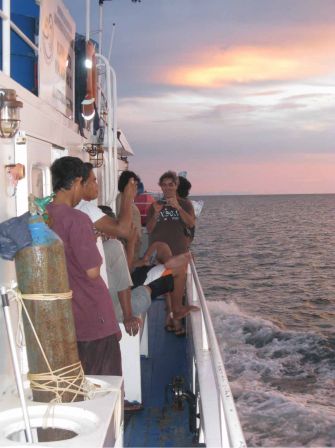 soyons clair des photographes de couchers de soleil – j’en suis) sont légions sur le bateau, avec les nuages équatoriaux au rendez-vous, c’est grandiose.
 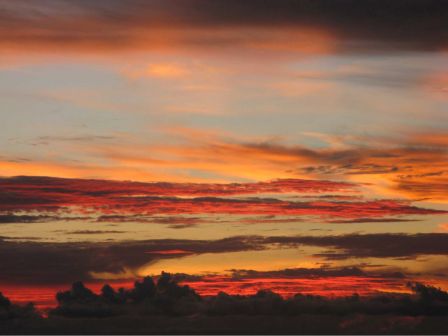 Sinon et enfin, autant mes compatriotes sont parfois bavards, autant il est de plus en plus difficile de leur faire prendre le clavier…
Heureusement, les collègues indonésiens (parfois tout aussi prolixes) répondent à mon appel. Ce soir, c’est Budi, mon collègue géologue de l’ITB à bandung qui nous livre son mémo sur le temps passé en baie d’Arguni…
Olga Otero, attendant demain et cette nouvelle baie que nous découvrirons au réveil.
My expedition to Lengguru Karst
By Budi Brahmantyo
It is started in the middle of the night at Jakarta International Airport Soekarno-Hatta when an airplane took us to Ambon in October 28th. At Ambon Pattimura Airport we changed airplane to Nabire and landed at Kaimana in the same day. We made shifting with the participant of expedition of phase 1 directly at the airport of Kaimana. On that time, I met Mr. Sinung Baskoro who looked very dark. The result of sun expose during the expedition. He smiled big when I asked how the expedition was. On the following days then I knew what the meaning of Mr. Sinung’s big smile. Perhaps he is now keep smiling and saying: enjoy the expedition of a lot of walking and hard adventure!
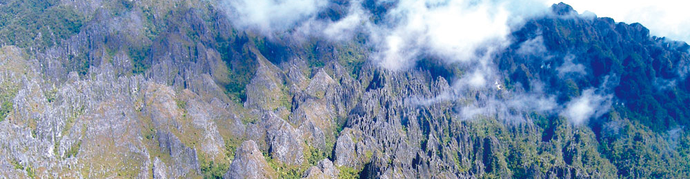
Yes it is hard expedition. With almost all area have undeveloped accessibilities, to reach a site target; we have to go by long walking or taking boat. And this is phase 2 of the expedition at Arguni Bay, north of Kaimana. Geologicaly the Arguni Bay area consists dominantly by Lengguru limestones. Tectonically it influenced by the series of thrust-fold belt trending northwest – southeast. The geological condition makes the landscapes of Lengguru karst are very rough. Karst terrain decorated by high steep cliffs.
Some of them are vertical cliffs. On the next day, for the first time I climbed that karst condition to check one doline at Sewiki Lake area. Together with Gilhiem and Bruno and accompanied by two local people Robert and Anton, we observed the doline that has more than 50 m deep. I had to take a deep breath when explore the doline because of its terrain. Loose blocks of hard limestones in steep slopes have to be passed through in the exploration. Unlucky for me, my walking shoes are broken on the previous day so I had to change to rubber boots that made my stamina lose much.
However, prior to the exploration, the problems with traditional rules made us got hard feeling. The local people gave a condition that we must get permits from the authority of both administratively, traditionally, and the underworld. After waiting for two days just for the permits, we then could work freely at the place called Jabuenggara, the place where two caves and two dolines exsisted.
But, another problem came from the lady who visited us from far in Jayapura just to warn us that the expedition must not began without her permission. Coincidently, on that day, only I who then became a target of her complain since Kadarusman as well as Laurent as as expedition leaders were not at site. I explained her as good as I could about the object of the expedition. In fact her argumentation met wrong target because we work not on her land at Sewiki Lake that although we too have plan to work at Sewiki Lake but as far not yet conducted. Finally I promised her to get meet with the expedition leader at Urisa village in the afternoon. What the funny was the lady is the mother of my ex-student in Department of Geology ITB years ago. His son now works as a provincial staff at Papua Barat Province. That’s why she, who has high position in Papua level (ex-parliament member), was intend to meet me because of that relationship. So we said goodbye each other with big smile.
After all problems gone out, the works were continued. And… we took exhausted walking passing through swamp thick mud to prove of brackish spring from limestone again with Guilhlem and Bruno. No prove of what was reported by local people. Robert said because we were at the time of rainy season, the phenomenon do not happen. But that still big wonder if it was true.
Besides karst work, I also help Olga and Unggul who work to search sediments. At first we were just check out geological data that was mapped in geological map. But if only checking out old data, of course it was not something new. So I had an idea to measure stratigraphic profiles of every series of outcrops so that we can tell the history of sedimentation. One of big discovery that Olga wanted very much was to find continental source and it was at Warumi (Warum) Island within erosion surface of basal conglomerate. Near to the end of the expedition in Arguni Bay, I was so much exhausted after long walking following the new open road to Kaimana in looking for karst phenomenon where rivers in and out through caves. 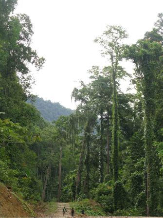 That was my impressed expedition around Arguni Bay. Along the day of expedition, especially when stay nights in the jungle, what still remain in my mind is the sound and environment of the jungle, because this is the real tropical rain forest with high humidity and wet that not existed anymore in the jungle of Java where I live. Even at night we still feel hot weather. Under the shelter of limestone wall at Wababoko cave, I took off my t-shirt as the Frenchmen and local people did. From the last photo, it is funny that we were just like prehistoric cavemen all together in the same place, same time, of Mongoloid-man (me), Australoid-man (Papua local people), and Neanderthal-men (the Frenchmen):).
 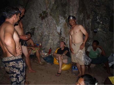 By Budi Brahmantyo
Ha ha ha » Neanderthalmen » Elle est bien bonne celle-là !
ça vaut bien les » grotteux » no ?
On sait toujours pas comment vous ramenez vos « poissons »
Un salut pluvieux mais glacé du Nord
D’Jack